Jornada researcher Niall Hanan and colleague Julius Anchang recently published a News and Views piece in Nature. The authors describe how technological advancements and higher spatial resolution of satellite imaging could potentially map individual trees on a global scale. The article can be accessed at https://www.nature.com/articles/d41586-020-02830-3#ref-CR2.
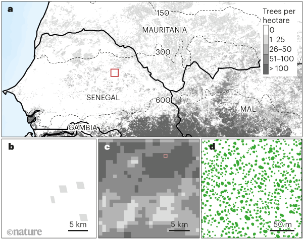
Figure 1 | Large-scale tree mapping. Accurate information about tree distribution provides useful ecological insights, but such data are difficult to obtain for large areas of land. a, A previous study2 estimating global tree density per hectare relied on data from field plots — samples of these data are shown for western Africa. The inset box in a is in a dry region (with an average annual rainfall of less than 600 millimetres per year), and corresponds to b. Dotted lines indicate the boundaries of average rainfall in millimetres per year. c, d, Brandt et al.1 report the detection of individual tree canopies across western Africa, obtained using an artificial-intelligence approach to analyse high-resolution satellite images. The authors found a higher tree density in dry regions of Africa than did the earlier study. For example, Brandt and colleagues’ analysis of the area corresponding to the inset box in a produced the tree density per hectare shown in c. They identified the size and location of individual tree canopies (green), as shown in d for an area corresponding to the inset box in c. Tree information at this level of detail was not available in the earlier study. (Images made using data from refs 1 and 2.) (Springer Nature remains neutral with regard to jurisdictional claims in published maps.)